Mapping Justice: Florida
Designing Geospatial Tools for Social Change
FREE Environmental Justice & Data Science Virtual Summer Course for Florida High School Students
Why Mapping Justice?
Learn about Environmental Justice and how you can make a difference in your community
Gain marketable geospatial data science skills, including how to analyze data and create an interactive digital map
Explore topics like climate change, pollution, water quality, coastal erosion, community resilience, and more.
Create and present a final group project on an issue you care about
Earn COLLEGE CREDIT FOR FREE from University of Massachusetts Global
“Even though I have never left Florida (and have been saying for years I will graduate and never come back to this state), this honestly made me never want to leave. Now I want to know everything there is to know and figure out how I can help real people and bring education and awareness to others. I also said I never wanted to be a teacher, but I’ve discovered I really like sharing my knowledge.”

“When the guest speakers talked about the ways they used ArcGIS, they showed they used tech as a tool for change. That showed me that there wasn’t a linear path that I had to take, which was one of the reasons I had steered away from STEM classes.”

trubel&co creates learning environments where students leave with increased technical proficiency, a concrete understanding of the role identity & place play within STEM, and an opportunity to design & implement their own vision for civic change.

“My definition of climate justice has changed throughout this course in that it is no longer as limited as it was before. I used to think climate justice was limited to court rooms and lawmakers, that there was very little the layman could do to enact change. I see now that something as simple as educating and gaining knowledge can create real change. This course helped me to be an active participant in a climate justice movement.”

“I’m proud of finally understanding the practical use of the analysis tool, ever since understanding how to use it I’ve been thinking of more and more ideas to apply it to.”

Interested in sparking good trubel in your area?
We hope to hear from you!
We are actively building partnerships in Florida to accelerate access to justice-oriented STEM education. Potential sponsors, professional volunteers, and prospective applicants are encouraged to contact us directly.
Send a note to: hello@trubel.co
Mapping Justice Builds
Core Competencies
-
Measuring academic performance and continued engagement with STEM coursework over time
-
Awareness of careers within STEM & innovation; preparedness and retention indicators within such fields
-
Ability to communicate technical insights with broad population; ability to collaborate in diverse teams
-
Comprehension & comfort with applying new technical skills to create innovative solutions
-
Ability to identify societal inequity, understand their root causes, & motivation to take action
-
Confidence in their capability to work through ambiguity & solve complex problems without giving up
Mapping Justice champions diverse high school youth to design geospatial tools for social change, using GIS (Geographic Information Systems) to promote equity within their community. In the course, students focus on technical skill building, critical consciousness, and civic innovation.
Instruction on Geospatial Data Analytics
GIS enables multiple technical pathways, including data analytics & visualization, product design, coding, and urban science, building critical skills applicable to a variety of careers.
Curricula on Race, Power & Technology
Facilitators guide learning on responsibility/ethics in STEM, and on how identity & place impacts innovation. Learn more about our approach here.
Self-Directed Student Capstone
Students create maps, dashboards, and digital apps that utilize geospatial analytics to tackle complex community-based challenges tied to identity, place, and areas of passion.
Why GIS?
The geographic approach has enabled students to explore many social issues with data.
In class, students frame, visualize, & grapple with complex problems with real world implications.
In the field, GIS is used to drive decision-making across industries to assess both macro & micro questions around the “where” of their operations.
Esri, the leading geospatial technology provider, has partnered with trubel&co to expand access to GIS and spatial thinking since our beginning.
Educational benefits for students who use GIS

-
Spatial thinking is crucial to understanding our increasingly interconnected, complex world, and it’s key to solving the serious problems we are facing in that world.
-
GIS is a natural system for teaching critical thinking skills. Students who learn GIS are better equipped at utilizing data to uncover trends, tell stories, and solve complex issues.
-
Students empowered with the skills, content knowledge, and perspectives gained from GIS instruction like Mapping Justice have the confidence and ability to become change agents in their future workplace.
-
When students use GIS and geographic inquiry to grapple with problems, as Esri and Mapping Justice instructors have witnessed thousands of times over the past 20 years, students engage in five key fluencies. Creating interactive maps alone is key to creative fluency, and thinking critically about maps is key to success with media fluency as well as many aspects of modern life.
Learning Outcomes
Each cohort moves on from Mapping Justice with the awareness of how geospatial tools can advance a social mission and understand the power of responsible technology.
After completing this course students will have successfully:
Developed their potential in spatial analysis via ArcGIS, building technical literacy in the applications of data and furthering competency in analytics (e.g., data collection, cleaning, analysis, interpretation, visualization)
Explored the realm of justice, responsible tech, and how spatial data enables social movements and liberation (through both a historic and modern lens)
Created a visualized dashboard (e.g., series of maps telling a story) that is visually-compelling, impactful, and advances the development of the issue
Improved their ability to devise & communicate a research plan and its outcomes
Enabled one’s self-efficacy in self-directed learning & proactive development
Explore Mapping Justice Capstones
by Amber Irwin
Coral bleaching is an issue that has a wide variety of impacts but silently occurs in the background of daily life. I was introduced to it in a freshman-year geography class I had taken. I was confused as to why, if this was such a big deal, especially to Florida, I hadn't known about it. I was appalled when I discovered that I wasn’t the only one unaware, it just isn’t a widely discussed topic. Since that semester-long class, I’ve done personal research and fit the topic into any paper or presentation I could in school. I’ve wanted to go deeper and learn more about it so I can share with, and educate, as many people as I can and hopefully have action taken. It’s crucial to our environment, society, and quality of life to address the issue before it goes beyond repair.
Living in Florida, I’ve seen all of the news reports telling residents that we’re reaching new record-high temperatures and that our oceans are warming up. It’s all we’re surrounded by and it’s falling apart. A lot of people aren’t even aware that coral is a live organism, let one knowing that they can bleach when water conditions are bad. Without people having this knowledge the issue can’t be solved and will only continue to get worse and do more damage to Florida’s structure.
Wastewater’s Contribution to the Coral Bleaching Crisis

The Price Of Climate Change & Inequality: Communities don't experience natural disasters equally.
By Lindsay G, Daniella R, & Esmeralda V
As Floridian students, we are witnessing firsthand the devastating effects of climate change on our community, Hurricane Ian, for instance. Our project aims to delve into the impact of disasters and gentrification on low-income and minority households.
Unfortunately, these issues disproportionately affect communities that are often neglected regarding government funding for education, public transit, and other essential public facilities. As a result, many families are forced to leave their homes due to rising prices or are pushed into underfunded areas. The most vulnerable groups, people of color and those from low-income backgrounds are hit hardest by gentrification (Misra, 2019). This reinforces a cycle of inescapable poverty, but in recent years has been amplified by climate change and increased natural catastrophes.

by Cristina Baten-Hernandez
Through the use and visualization of data, we can provide people with a deeper understanding of those who are impacted. It enables us to observe trends and changes within communities or states and identify those who are most vulnerable to rising temperatures and heat changes. These factors are crucial to consider in order to provoke change in those impacted and those who might know someone impacted.
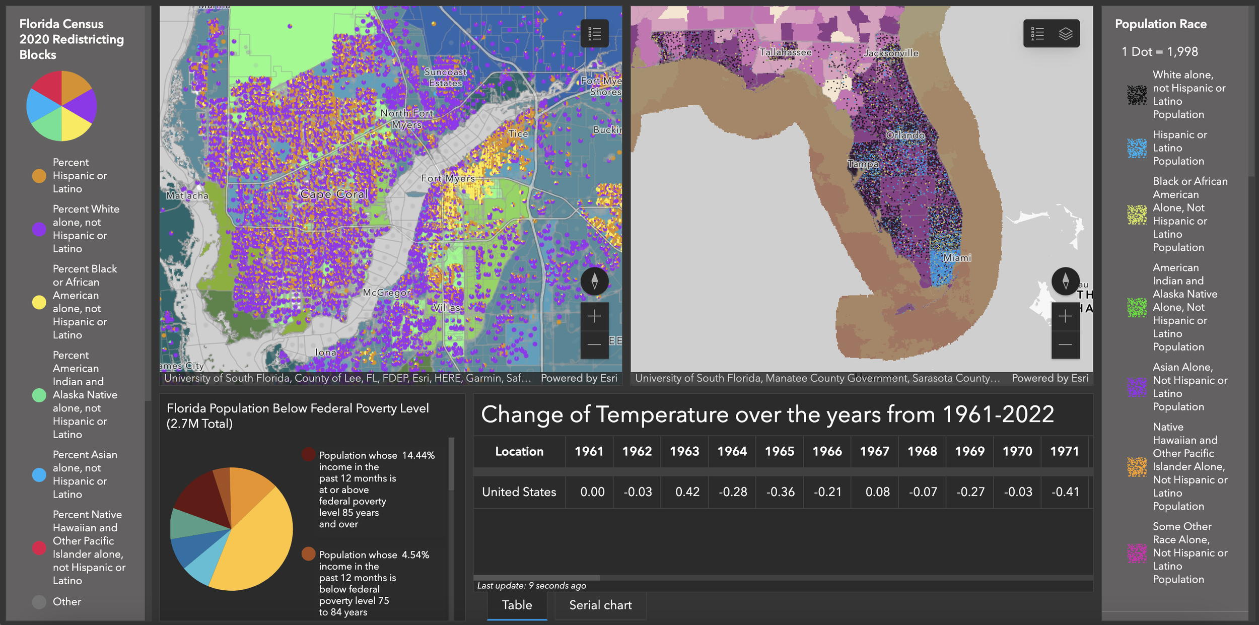
Historical data can be used to see where changes started and what could have caused those certain changes, for example, through the research of increased Co2 emission and other gasses we could see correlations between climate change and the rise in temperature in certain locations. What I focused on was the location that is relativity high with more minority races in locations of high heat risk and areas of poverty using more of household income to determine the injustice they face.
Rising heat impact of high temperature on Florida vulnerable populations, particularly more at-risk elderly, children, & people of color
by Ocean Dowd, Ann Gracy Satyr, Aalayah Meran
In our project we hope to provide an in-depth and visual demonstration of how climate change facilitates coastal erosion, and how that coastal erosion damages properties along the coast. This issue is of sizable importance to coastal communities because it can be disadvantageous to disenfranchised communities such as low-income residents who live further inland. As historically higher-income communities along the coast begin to move inland due to property damage, residents who have less money will be bought out of their communities and homes. This has the potential to affect a wide variety of disenfranchised peoples such as people who are low-income or racially prejudiced against who tend to live further from the coast. The scope of our project, although Florida specific, includes a wide variety of Florida’s residents. Approximately 15 million of the 19 million Florida residents live along the coast, that’s about a whopping 76.5% of Florida! This is due to impact all of Florida’s coastal communities, regardless of their socio-economic background. As even those that are more well-off will still suffer from the loss of land and property damage. Although this issue is by far and large an after-effect of climate change, it is being systematically exacerbated by the lack of governmental support. No one is directly responsible for this issue, but it is our collective duty to learn more about the issues impacting our community.
As residents of Florida who live along the coast we considered about what coastal erosion will do to our environment and our way of life. We want to educate people on coastal erosion so that we can all do our part to help our environment and our people.
Coastal Erosion in Southwest Florida: an analysis with implications for all of Florida
